


Education has come a long way from traditional textbooks and chalkboards. In the age of technology, educators and parents are constantly seeking innovative ways to engage students in the learning process. One such method gaining traction is the use of 3D wooden world maps as tools for interactive and immersive learning experiences. These maps are not just decorative; they serve as educational adventure platforms that foster curiosity and deepen understanding.
Here, we delve into the world of educational adventures and explore how 3D wooden world maps are transforming the way students learn about geography, history, and culture:
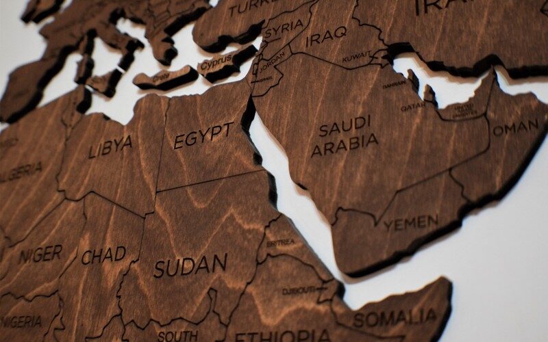
- Tactile Learning: 3D wooden world maps provide a tactile learning experience that engages multiple senses. Students can touch, feel, and manipulate the map’s contours, fostering a deeper understanding of geographical features such as mountain ranges, valleys, and bodies of water. This hands-on approach enhances retention and comprehension.
- Geographical Awareness: Interactive maps offer a comprehensive view of the world’s geography. By exploring these maps, students develop a spatial awareness that goes beyond memorizing place names. They gain an appreciation for the size, location, and relationships between countries and continents.
- Historical Context: Many 3D wooden world maps include historical information, such as trade routes, explorers’ paths, and empires’ rise and fall. This contextualizes geography within the broader scope of history, encouraging students to connect geographical features with historical events and societal developments.
- Cultural Exploration: Wooden world maps often incorporate cultural elements, such as indigenous artwork, landmarks, and historical facts. This invites students to explore the diversity of cultures around the world and fosters cultural sensitivity and curiosity.
- Language Learning: Maps can serve as a foundation for language learning. Students can label countries, capitals, and geographical features in different languages, promoting multilingual skills and cross-cultural understanding.
- Critical Thinking: 3D wooden world maps encourage critical thinking and problem-solving. Students can analyze spatial relationships, evaluate the impact of geographical factors on historical events, and make connections between different regions and cultures.
- Teamwork and Collaboration: Using large 3D maps in group settings encourages teamwork and collaboration. Students can work together to solve geographical puzzles, plan imaginary journeys, or simulate historical events, fostering social and cooperative skills.
- Global Perspective: These maps inspire a global perspective. They remind students of the interconnectedness of our world, emphasizing the importance of global issues, such as climate change, international relations, and cultural exchange.
- Customization and Creativity: Some 3D wooden maps are customizable, allowing educators and students to add their own details, markers, or interactive elements. This creative freedom enhances engagement and ownership of the learning process.
- Long-Term Utility: 3D wooden world maps are not confined to the classroom. They make excellent additions to libraries, community centers, and even homes. This long-term utility ensures that learning can continue beyond the school environment.

In conclusion, 3D wooden world maps represent a dynamic and immersive approach to education that goes beyond traditional teaching methods. They stimulate curiosity, deepen understanding, and inspire a lifelong love of learning about our world. By providing a hands-on, interactive, and multi-sensory experience, these maps empower students to become global citizens who are informed, culturally aware, and eager to embark on educational adventures that extend far beyond the boundaries of the classroom. As educators and parents continue to seek innovative ways to inspire young minds, 3D wooden world maps stand as powerful tools for shaping the next generation of informed and engaged citizens.
Source: just-likewood.com